THE LOOP – James Griffin
Ellen asked me to write something about the cross country run one can do to include Maple, Prevost and Tzouhalem mountains. I’ve put this together, including personal reminiscences, as a contribution to “Ceevacs Connect”.
As I remember (and the old sometimes forget), for maybe 10 years I usually ran the course every year, initially making a few changes. The route eventually stabilised. I think I last ran the course 3 years ago (2017). I have been torn about whether I will try the course again: If I do, it would certainly be at this time of the year.
Standing in the middle of Chesterfield Sportsplex you can see the three main mountains (Maple, Prevost and Tzouhalem) which surround The Cowichan Valley. We are incredibly fortunate in North Cowichan to have the bulk of these mountains incorporated as working Municipal Forests that have been so well organised for all our interests for many decades. It was just before my 60th when I looked up from the Sportsplex and figured it might be possible to run a loop from our house in Maple Bay to include these three peaks. I had run somewhat on the trails of all three mountains over the previous years, and I guessed that 9 hours would be a good time to aim for. It was on my 60th birthday that I first set off.
I might say at the outset that I am sure anyone who knows these mountains to any extent, likely has a strong sense of the individual character of each mountain. They really are quite different, but I realise our perception of the differences are due in large part to what we ourselves take to the mountain. Still, I will say that I have always felt most at home on Maple Mountain. It has for me a sensation of unfathomable age, and there are nooks and crannies where you could be safe if you were attacked by goblins, for example. It doesn’t really care about you one way or another, but it is in no way unfriendly. I feel very differently about Mt Prevost, which despite all its attraction visually, always makes me uncomfortable. It keeps some nasty secrets and I am happy to get off it. Mt Tzouhalem is more straightforward, is the most spectacular visually, and will adapt itself to humour you.
On my first attempt I set off before 07:00am with a camel back full of Gatorade, a Cliffs Bar and a handful of dates. I’ve always followed this routine, and it has worked well for me. I don’t like running with a camel back, but I can put up with it. In the last 10 years or so I have been lucky enough to have my wife, Laura wave me off and tell me to phone her at work when I get back.
Running along Arbutus Avenue and up Maple Mountain Road, I start on the Maple Mountain’s Blue Trail. The first time I tried this part of the loop, my friend Tammy joined me and that was before she ran away from home to join the RCMP. It was a very cold morning, and we missed the curve in the trail and continued under the power lines getting lost in the heavy broom that had developed. We had to back track. Maintenance under the power lines has made the curve we missed more obvious now, but I always think at that point of the first time I was up here when Tammy had to help me get my frozen fingers back in my gloves, and I’ve always avoided the winter months ever since.
The Pink Trail curves off the Blue to the left just after the power lines: you can access the Pink again when it curves back nearer Crofton almost within view of the Mill where I used to work. This second access is what I used to take, but I’ve found it best to take the first access point, although it is easy to miss.
A straightforward climb, and the Pink connects to Maple Main, where you can turn left for a few hundred meters and arrive at the microwave station where I take my first break to suck Gatorade, munch on some dates and look down into Birds Eye Cove.
I return straight down Maple Main, past the section where I once brought my youngest, Dominic, tobogganing one snowy afternoon when he was young.
I arrive at Osbourne Bay Road. Here I cross and then run along Richards Main directly opposite. The first time I ran this route I didn’t know about a single-track path that runs off to the right a km or so along, but Ceevacs member, Darrell, then Municipal Forester, took time to meet me and show me where the path tees off. It is always pretty overgrown. Once I ran this loop when it was still a little damp out and my legs and shoes were quickly soaked, so I never try the loop now unless its bone dry out, for there is still a long way to go. This path leads through the woods and then an open area of clear-cut where the memorial cross on Mt Prevost is clearly visible dead ahead. Richards Main terminates on Richards Trail.
At Richards Trail I turn right, running to Westholme, left on Westholme, past Bell McKinnon and on to the Island Highway. I cross the highway. There is always lots of traffic, a little surreal after the quiet of the mountains, and the crossing seems exceedingly dangerous.
I run along Somenos, remembering one year when Kelly, another Ceevacs friend drove out to meet me en route. That was close to fenced land to the left which always looks to me like it should be a Kentucky horse farm, oddly placed in the Cowichan Valley.
Kelly and I ran together, turning off Somenos, up Mt Prevost Road and onto Mt Prevost Main. This is a pretty straightforward climb signposted (sort of) to arrive at the top of Mt Prevost. I usually figure I’m now about halfway, and it is usually about 11:30am. Once, the hang gliders were jumping off as I arrived, and it’s a good spot to pause, have a Cliff Bar and look around.
I descend Mt Prevost the same way I came up. I’ve considered, instead, taking one of the many trails that exist, but, as I said, I don’t choose to linger on Mt Prevost. I know some runners prefer uphill to downhill, but by this stage of the run I’ve developed a most
pronounced preference for the downhill sections, and I feel I’m somehow getting my own back on that slog uphill by going down the same way.
All good things come to an end, and I have often found that by the time I cross the Lake Cowichan Highway on Somenos, I’m having to walk quite a bit. It is also getting hot at the time of day that I’m out, and I make a note to avoid this run in the height of the summer. One of the first times I ran this course someone was installing posts to build a wooden fence around his garden just by where I had turned off Somenos an hour or two earlier. His fencing had progressed a little by the time I came off Mt Prevost that same trip, and it has stood for many years. But it is now looking pretty tumbled down. So, it passes.
I used to turn left off Somenos, onto the Lake Cowichan Highway and then south on the Island Highway. I don’t dislike heavy traffic on an ordinary run, but I do find the heavy traffic on the Highway disorienting at this stage, and the big trucks keep blowing my hat off, so I stick to Somenos. I turn left at Sherman, right at Canada to Beverly to the roundabout. I don’t know why, but I’ve never much liked running on the new dike. I stick to the road, go across the roundabout at Lakes, up Rosewood and Brier onto Tzouhalem.
Along Tzouhalem for a few km, I turn left through Providence Farm, past the horse barns and the blackberries and start uphill. The first time I ran this I missed the sharp left turn on the main trail and ended up bushwhacking to climb up the cliffs directly under the Cross, an experience I’m not keen to repeat. I spoke to Sheron later who told me to take the sharp left not long after leaving the farm, and this works much better, although it does take you up The Wall on the *Gut Buster. Once when running the Gut Buster, I meet Prairie Inn Harriers’ Carlos, ‘The Jackal’ having stopped up ahead of me to take in the view and chat to whoever choose to join him. I think about it and pass on.
It is a steady climb to the Cross, and then pretty flat along the ridge to the Look Out. If you are up here at the right time of the year you can clearly hear music wafting up from the Folk Festival at Providence Farm.
I descend Mt Tzouhalem on “B”. In earlier days of this run, this section of the mountain hadn’t been clear cut and I knew the way back on the trails that our Ceevacs Monday Mt Tzouhalem group used to run. But after the clear cutting, things changed. The second time I did the loop I had come up “Kingsview instead of through Providence Farm, and I had dropped into Jim M’s house in The Properties for a drink. He joined me for an hour or so, running up and then back down together, but we got a little disoriented when we arrived into the then-new clear cut. It was getting on towards evening and I didn’t want to get off the mountain too far away from Maple Bay, so we had to wander around a bit in that moonscape before descending. As I remember, the old trails had been obliterated. Later, Sheron suggested a **mountain bike path leading off to the right immediately before the clear cut, and I’ve taken that ever since.
After a seemingly endless descent, this path comes out at the top of Nevilane Drive. Then, it is straight down Nevilane Drive and Osprey onto Maple Mountain Road and so home.
Home means lots and lots of hot sweet tea with soft boiled eggs, homemade bread and Marmite and then strawberry jam, a soak in a bath and a nap. Then up for supper with a bottle of wine, and bed.
By the way, I’ve never made that 9 hours, not by quite a long shot, but maybe I should try again. But not in winter, not when it is at all wet underfoot and not in the heat of summer. That means about now…Hmmm…Dragons live forever, but not so little boys…Maybe some things are best left alone.
Thank you, James Griffin for documenting your experience on the Loop.
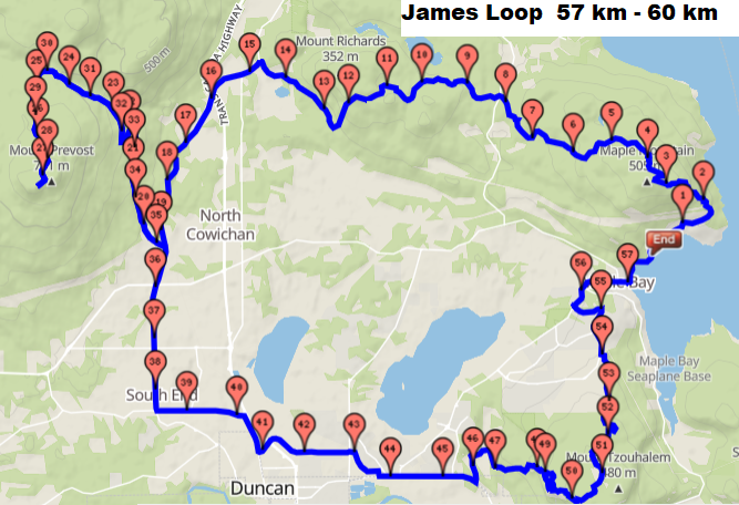
• Gmap of James Mountain Loop: http://www.gmap-pedometer.com/?r=7503928

P.S. from Ellen
James continues to run at 73 years old. I asked him what he’s been doing lately, and he said, “A couple of months ago I was following a training programme I had cobbled together for the North Olympic Marathon in Washington State. I maintained the programme up to the date of the planned event in early June, although it was clearly going to be cancelled, or, in any event, I clearly was not going to go there!”
James:
“Sheron may be able to draw a good map, I believe. My efforts floundered because many of the trails I couldn’t find on existing maps. They had to be substituted by straight lines, which were both very inaccurate and odd-looking. “
Ellen
“For those of you who are not familiar with the Cowichan Valley, Sheron has added a map that shows what James has described to give you a visual sense of The Loop.” Thank you Sheron.
P.S. from Sheron:
*GutBuster Trail Series is now the Vancouver Island Trail Series
** The mountain bike path formally named the ‘Muni Trail’ is now called, ‘Bumble Bee’. The top section of the Bumble Bee trail designated for downhill mt bikers.
Photos:
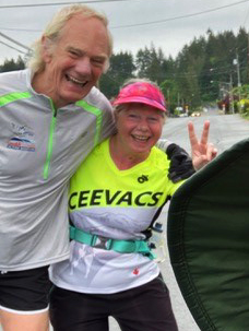
– Laura (wife) and I ran the Lock Down Relay from Maple Bay to meet Ellen and Bill on May 30 /20. There were 3 spokes: Maple Bay/Crofton/Chemainus to Mt. Prevost school, the second one from Shawnigan/Mill Bay to Mt Prevost School and the third from was from Lake Cowichan.
– The photo was, I believe, taken on the trail between the Cross and the Lookout on Tzouhalem, when I was collecting trail ribbons used to mark the Gutbuster Run (hence the garbage bag!). When running the Loop, this was a very happy stretch for me as I was now confident that I would be finishing.
– I was training at the Sportsplex wearing my Edge to Edge t-shirt.
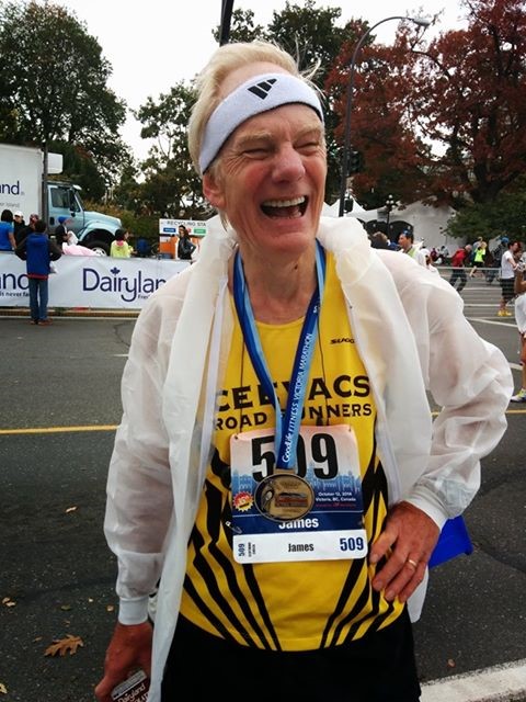
– I came in 5th in my age group in the Victoria marathon 2014.
– This photo has, as I’m certain you know, Mt Prevost in the background. I always find that (Somenos) dike such a damn slog, and I think it shows, doesn’t it!


